About Turf.js
Project started and managed by Morgan Herlocker (now at Mapbox)

James Seppi | @hydrologee
MaptimeATX - June 10, 2015
Presentation at MaptimeATX
Viewable at maptimeatx.github.io/intro-to-turf
Source code at github.com/MaptimeATX/intro-to-turf/
JavaScript library for geospatial analysis
Runs in web browsers, or in Node.js
Open Source, MIT-licensed
Collection of small modules
Aggregation, Measurement, Transformation, Interpolation, Classification, Joins, Types, and Helpers
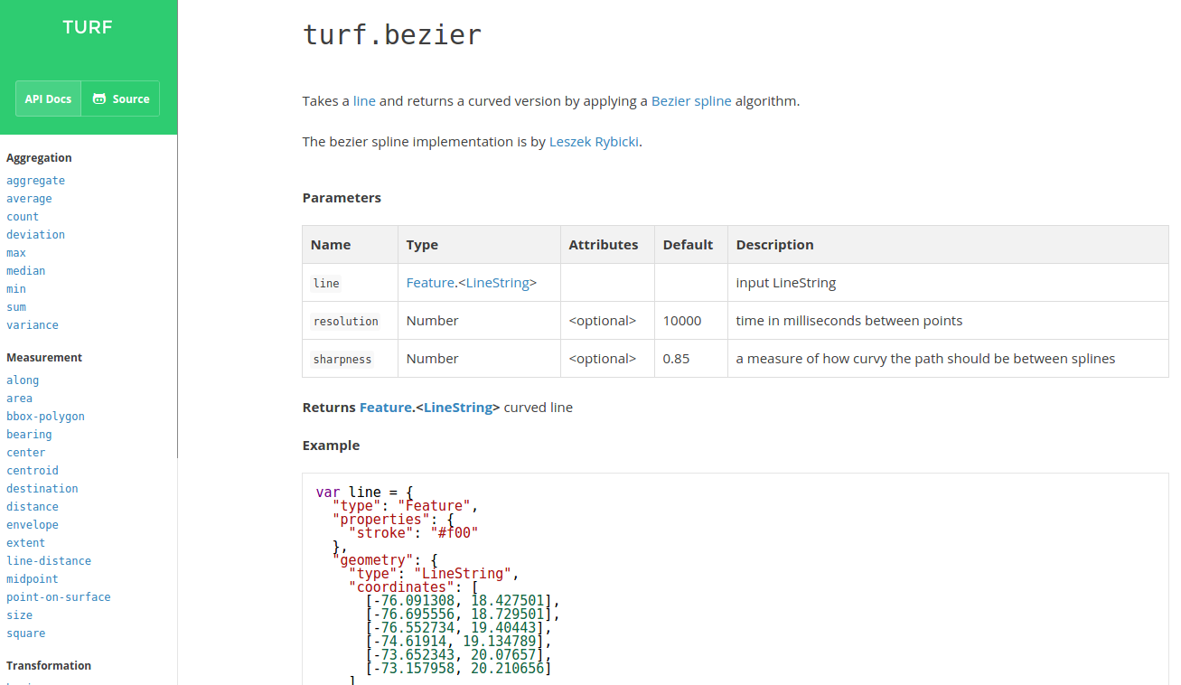
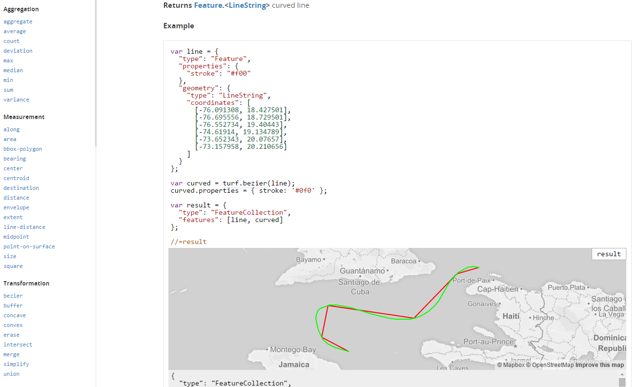
turf-area
turf-buffer
turf-distance
turf-intersect, turf-union, turf-merge
turf-aggregate, turf-along, turf-average, turf-bbox-polygon, turf-bearing, turf-bezier, turf-center, turf-centroid, turf-combine, turf-concave, turf-convex, turf-count, turf-destination, turf-deviation, turf-envelope, turf-erase, turf-explode, turf-extent, turf-featurecollection, turf-filter, turf-flip, turf-hex-grid, turf-inside, turf-isolines, turf-jenks, turf-kinks, turf-line-distance, turf-line-slice, turf-linestring, turf-max, turf-median, turf-midpoint, turf-min, turf-nearest, turf-planepoint, turf-point, turf-point-grid, turf-point-on-line, turf-point-on-surface, turf-polygon, turf-quantile, turf-random, turf-reclass, turf-remove, turf-sample, turf-simplify, turf-size, turf-square, turf-square-grid, turf-sum, turf-tag, turf-tin, turf-triangle-grid, turf-variance, turf-within
Uses GeoJSON for all data in and out
Geographic coordinates (WGS-84) only
This means you must first reproject and transform other data formats to GeoJSON to use it in Turf
Standard format for geospatial data on the web
Point, LineString, Polygon, MultiPoint, MultiLineString, MultiPolygon, GeometryCollection
Feature, FeatureCollection (store properties with geometries)
{
  "type": "Feature",
  "geometry": {
    "type": "Point",
    "coordinates": [-97.74306, 30.26715]
  },
  "properties": {
    "name": "Austin",
    "population": 885400
  }
}GitHub renders it: github.com/tnris/tx.geojson
In Node:
npm install turf
//or npm install turf-buffer
var turf = require('turf');
//or var buffer = require('turf-buffer');
On your web page
<script src="//api.tiles.mapbox.com/mapbox.js/plugins/turf/v2.0.0/turf.min.js">
</script>
<script>
  var bufferedPoint = turf.buffer(myPoint, 5, 'miles');
</script>Word of Warning: Having too many points or complex features will make rendering or non-responsive
For larger datasets or complex analysis, it is better to do analysis on back-end
var austin = turf.point([-97.743061, 30.267153]); //GeoJSON point
var buffered = turf.buffer(austin, 15, 'miles');
result = turf.featurecollection([austin, buffered])var austin = turf.point([-97.743061, 30.267153]); //GeoJSON point
var atxBuffer = turf.buffer(austin, 15, 'miles');
var roundrock = turf.point([-97.678896, 30.508255]);
var rrBuffer = turf.buffer(roundrock, 15, 'miles');
result = turf.union(atxBuffer.features[0], rrBuffer.features[0]);var austin = turf.point([-97.743061, 30.267153]); //GeoJSON point
var atxBuffer = turf.buffer(austin, 15, 'miles');
var roundrock = turf.point([-97.678896, 30.508255]);
var rrBuffer = turf.buffer(roundrock, 15, 'miles');
result = turf.intersect(atxBuffer.features[0], rrBuffer.features[0]);//City of Austin Historical Landmarks
// from https://data.austintexas.gov/Geodata/Historical-Landmarks-Map/6k54-2nnj
display = landmarks.type;
display = 'Num Points: ' + landmarks.features.length;
result = landmarks;Download the Historical Landmarks GeoJSON at maptimeatx.github.io/intro-to-turf/data/landmarks.geojson
var bbox = turf.extent(landmarks);
var grid = turf.squareGrid(bbox, 0.5, 'miles');
var counted = turf.count(grid, landmarks, 'pointCount');
result = counted;var bbox = turf.extent(landmarks);
var grid = turf.hexGrid(bbox, 0.5, 'miles');
var counted = turf.count(grid, landmarks, 'pointCount');
result = counted;Documentation is a top priority for the Turf project
Built directly from the source code
Interactive examples!
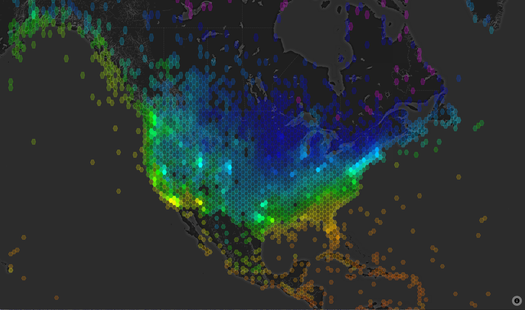
Average Temperature by Jordan Rousseau
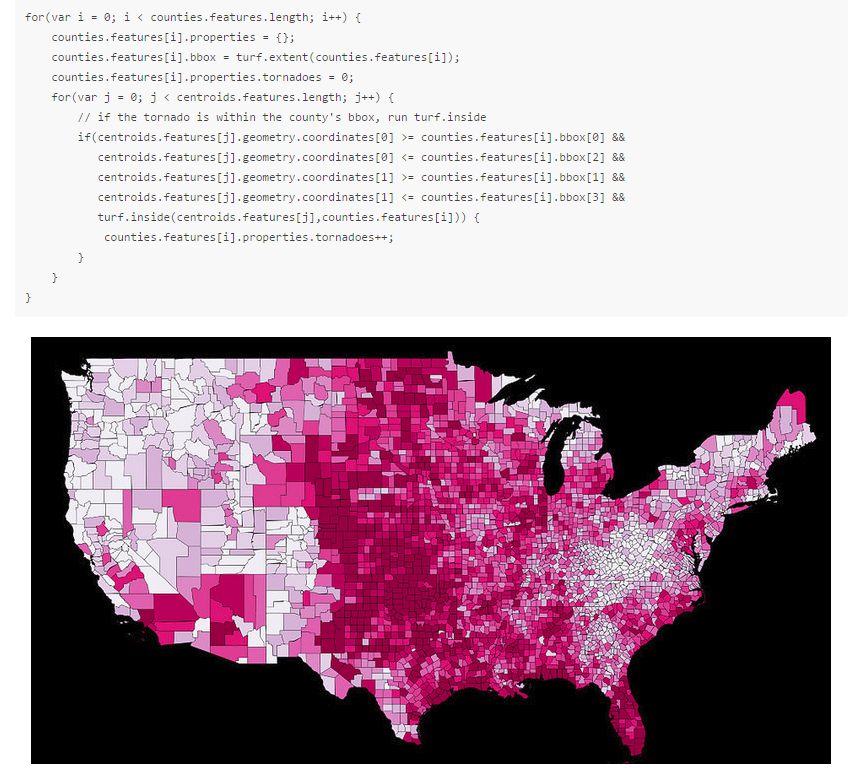
Analysis of 60 Years of Tornadoes - mapbox.com/blog/60-years-of-tornadoes-with-turf
57,988 tornadoes analyzed over 3,221 counties (in Node)
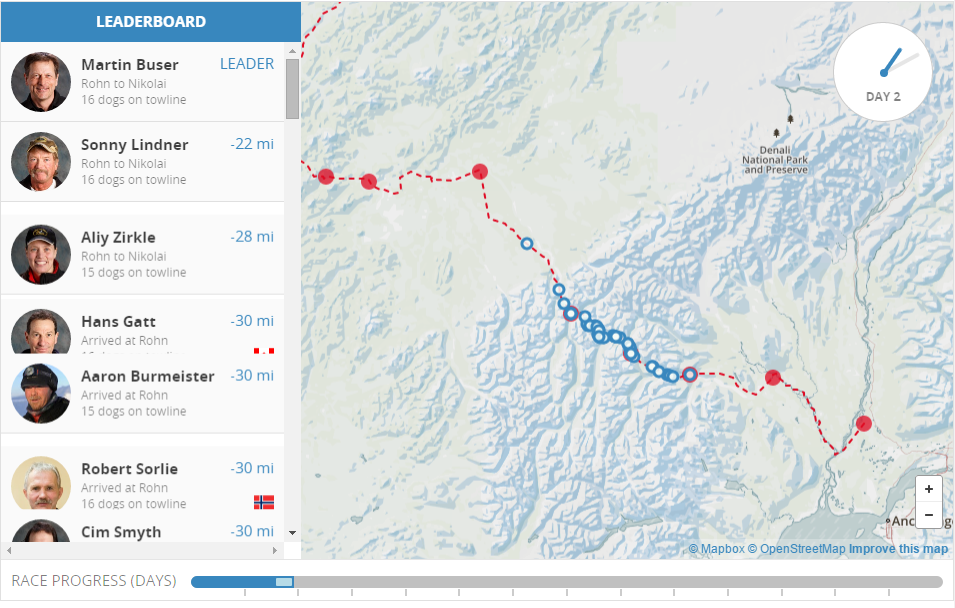
Iditarod Visualization - mapbox.com/blog/playback-the-iditarod-with-turf
Open Source, developed in the open on GitHub: github.com/turfjs
Still more work to be done: docs to improve, code to write, bugs to discover, tests to write
Check out the issues: github.com/turfjs/turf/issues
jsfiddle.net/jseppi/grwh8kmx/4/
Pair up with some (new) friends. Try to have a JavaScript person in each group.
Work together. Ask questions. You can do it!

Austin Historic Landmarks
Austin City Council Districts
Don't Peak!